Time of the year: from summer to autumn
Duration: about 2:35 hours
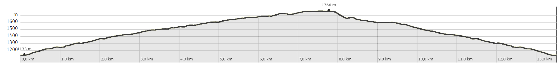
Length: 13,5 Km
This spectacular route runs mainly on forest roads, but also includes technical sections on paths. The pristine forests and pastures of the western Lagorai chain contribute to its charm, as does the opportunity to enjoy pleasant stops at Malga Vernera.
Author’s recommendation
ATTENTION: follow the gpx track and the indications on this page; the signposting of the routes is currently being positioned.
On the route there are refreshment points with seasonal opening: Malga Vernera and Baita Monte Pat (check if already opened)
Possibility of a long variant: once you reach the Vasoni forest road, loc. Dos di Camoré, you can proceed left to Malga Vasoni Bassa and Malga Fregasoga, following the Cuore Lagorai tour no. 868 back to Brusago. From here, return to Montesover.
Also suitable for E-mtb.
The route in detail
We start in Montesover just north of the church, on the road leading to Baita monte Pat and Malga Vernera, and proceed on a steep asphalt road, ignoring various forks with dirt roads. You thus quickly reach an altitude of 1400 m after about 3.5 km. Continuing on asphalt with a less demanding gradient in the direction of Malga Vernera, ignore the junction for Valfloriana and leave Baita Monte Pat on the left (refreshment point with a pleasant view). After about 2.5 km you reach Malga Vernera Bassa (1676 m): the view opens up among the meadows used for grazing, dominated by a small alpine church. Continue along the forest road (signpost no. 468 SAT) on a slightly uphill slope. At a crossroads, leave trail no. 468 and continue to the right. Initially you will come across small constructions called "baiti": here the forest road becomes a path (468/B) and near the hump begins the rather demanding descent (of about 300m) that will take you to the forest road below. The tour continues to the right down a 'concrete' section to the crossroads that you travelled uphill to earlier, ending the tour at Montesover.
Learn more about the itinerary on Outdooractive
Learn more about all hiking itineraries
Image gallery